Fraser Valley – DECEMBER 10 UPDATE – The River Forecast Centre has upgraded a Flood Watch to a Flood Warning for Sumas River, Lower Fraser tributaries including the Chilliwack River, Skagit River and Coquihalla River and other areas of the Fraser Valley around Abbotsford, Chilliwack, Hope and east through Manning Park.
A Flood Warning means river levels HAVE exceeded riverbanks or will exceed them soon. Flooding of nearby areas will happen.
Stay clear of waterways
Don’t drive through flood waters
Pack grab-and-go bags
Status updates: bcrfc.env.gov.bc.ca
Get Prepared: PreparedBC.ca/floods
DECEMBER 9 FVRD UPDATE – The BC River Forecast Centre has upgraded the High Streamflow Advisory to a Flood Watch for the Fraser Valley. A Flood Watch means that river levels are rising and will approach or may exceed the bankfull level. Flooding of areas adjacent to affected rivers may occur.
Areas of Impact:
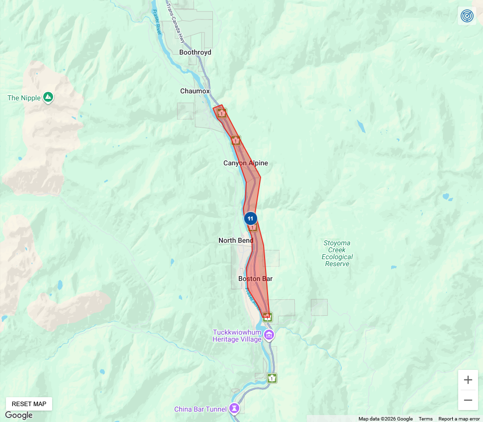
• Lower Fraser tributaries, including Chilliwack River, Skagit River, Coquihalla River, and other areas of the Fraser Valley around Abbotsford, Chilliwack, Hope, and east through Manning Park.
• Sumas River, including the potential for spillover from the Nooksack River. This is what caused problems in 2021.
Environment and Climate Change Canada has issued an orange level rainfall warning for Fraser Valley – Central. This warning forecasts 70 to 100 mm of rainfall from this evening (December 9, 2025) through Wednesday evening (December 10, 2025). Localized flooding is likely. Some roads may become impassable. Visibility will likely be suddenly reduced at times.
Areas of Impact:
• Fraser Valley- central, including Chilliwack and east including Hope, Hope Slide, and Highway 3 – Hope to Princeton (western sections).
ORIGINAL STORY – (BC River Forecast Centre) – Ministry of Water, Land and Resource Stewardship
Flood Watch – Fraser Valley (UPGRADE)
High Streamflow Advisory – Tulameen (NEW), Coldwater (NEW), Central Coast, South Coast, Vancouver Island
Issued: 12:00 PM December 9, 2025
The River Forecast Centre is upgrading to a Flood Watch for:
Sumas River, including the potential for spillover from the Nooksack River
Lower Fraser tributaries including the Chilliwack River, Skagit River, Coquihalla River and
other areas of the Fraser Valley around Abbotsford, Chilliwack, Hope and east through
Manning Park
A series of atmospheric rivers is impacting the United States Pacific Northwest and the south
and central coasts of British Columbia through this week. Observed rainfall since yesterday has
been in the 20 to 45 mm range for the South Coast and Fraser Valley and up to 70 to 100 mm
along West Vancouver Island. The next period of heavy rain is anticipated overnight on Tuesday
and through the day on Wednesday. While the highest precipitation amounts for these storms
are expected for Washington and Oregon, there is the possibility of heavier amounts moving
into British Columbia. Environment and Climate Change Canada have issued orange level
rainfall warnings through the region, identifying total precipitation amounts today 70 to 100
mm in the Lower Mainland, and potentially above 100 mm over higher terrain south and east of
Hope out towards Manning Park.